
All change

This gallery contains 2 photos.
April at Vauxhall gave us a surprise or two. It was a lovely morning for a visit to the foreshore, but we soon started to see some significant changes to the site. Whenever this happens, we tend to go through several stages of denial; Hmm, something looks different. Err, was that like that before? No. I’m […]
London Lupercalia*

This gallery contains 7 photos.
Cold and wind and rain. So just a typical February foreshore visit then. There was a little bit of feasting in the Portuguese cafe after our visit, but it wasn’t particularly riotous. Still, someone has been having fun. Today we were forecast a low tide of 0.31, not super-low, but not bad. I wasn’t hopeful […]
A chilly new year
We made our first visit of 2016 on a chilly, slightly drizzly January Sunday morning.
We were expecting a low of 0.37, so we were expecting to be able to see at least some of the prehistoric timbers in front of MI6. This was a fairly short visit, just a reccee really, to see what we could see.
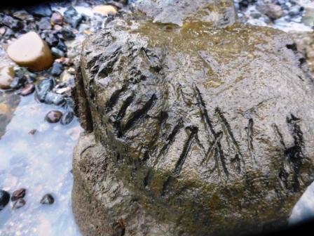
The tide was already pretty far out in front of MI6, so we were able to have a look at the first large timber.
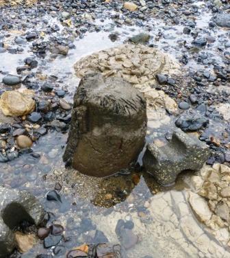
A lot of the bark has been stripped off by the wave action but it’s not in any danger. Looking at the top of the timber, there seem to be what look like chop marks in it. We wondered if it had been used as a chopping block in the past.
The tide was quite far out in the area around this timber so we waded out a bit to look for some timbers that we haven’t been able to see in a while.
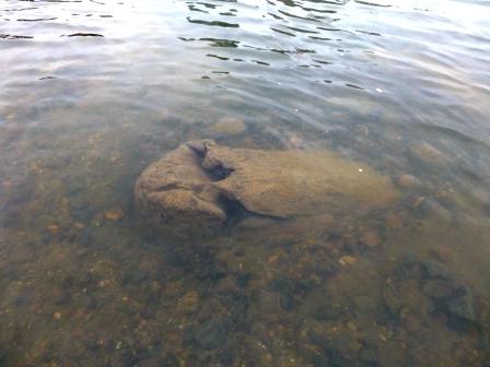
Under the water we could see three of the known timbers.
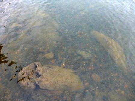
Ok, it was practically impossible to get photos that showed them all, but Roger helpfully indicated their positions. He’s standing right by the larger central timber and pointing directly at the other two.
Incidentally, this shows just how nice and clear the water is around here. It does cloud up with silt when the Clippers go past, but the water is often this clear, usually with very little floating rubbish in it. Those Thames Rubbish Eaters do a good job.
We weren’t able to see any of the other mesolithic timbers closer to the bridge because, although the tide did go out a fairly long way, the tide line has become increasingly uneven, perhaps due to erosion at different points. The level of low tide closer to the bridge was actually much higher than down near Lack’s Dock.
Just after the above photo was taken we realised that the tide had turned and was rushing in so quickly that we had to sprint to rescue our bags before they disappeared under the water. The tide actually came in so quickly that by the time we walked back to the first timber (only about 6o metres) the water had reached right up to it.
Cappuccinos called, so we went off to the Portuguese cafe to warm up.
In the bleak midwinter

This gallery contains 15 photos.
Dark, cold, threatening to rain. What’s not to like? It was very nearly midwinter when we made our last scheduled visit of 2015. Considering how rainy it’s been, you won’t be surprised to hear that the site was pretty muddy upstream of Vauxhall Bridge. As we had already planned to have a look at the dock […]
Spooky Vauxhall
Halloween at Vauxhall brought beautiful sunny weather but scaaaary mud.
Mud

Mud

More mud

Having taken a look at this from Vauxhall Bridge just before descending to the foreshore, I’d pretty well decided that I was having none of it. When I met Roger he had already seen it too and had come to the same decision.
So we decided that we’d do a bit of a recce upstream of Lack’s Dock and see how things were looking generally.
We are noticing that the contours of the foreshore in front of MI6 have been changing. The low water area of the foreshore (on the right of the image below) is being increasing scoured flat and it looks like a lot of the dislodged material is being pushed further up the foreshore (on the left of the image below).

Quite a lot of the layer nearest the low water mark still looks like a relatively recent industrial layer. There’s quite a lot of metal-work in it (I should say that ‘quite a lot’ is a relative term. This wouldn’t be considered quite a lot at, say, Rotherhithe, but here it’s a noticeable amount).
Roger particularly wanted to have a look at the chalk area immediately upstream of Vauxhall Bridge, as there has been a significant amount of scour there.
A lot of the chalk boulders have been broken up and are eroding out and we are seeing an increasing amount of barge-bed fill across the whole area. This means that we’re seeing more things like bits of clay-pipes, pottery sherds, old shoes etc. Today we found a discrete area which seemed to contain a lot of pottery kiln furniture and wasters.


We also saw a lot of animal bones. This area is tricky because the chalk barge-bed layer and the fill and packing underneath it seem to just merge into the layers below, where there is peat and a lot of shrubby roots and stems. Where we are seeing animal bone, we can’t always tell if it’s associated with the barge-bed fill or the peat layers beneath.

We didn’t take this bone out because it was home to a whole colony of shrimps!
Today we had a range of animal bones, mostly just on the surface, including this monster Scooby Snack.

So, as we head towards year’s end, we made some decisions about our next area of focus. We had wanted to continue drawing all the features on our alpha list, but the mud made this impossible. We can’t even see half of the box structures as they are lost in the depths.
So our focus has rested on this.

This is the point at which the River Effra flowed into the Thames (n.b. this photo was taken earlier in the year. On this visit, we couldn’t get near the dock entrance because of the mud). It was a water source and dock for industry. We have decided that we are going to draw this dock entrance, including the track support to the right (maybe the track for a small crane?). We also have quite a few images and map evidence for this dock so we’re working on a timeline for it. Doing this will help us to write a little illustrated potted history of the dock, and it has the benefit of forcing us to sort out some of the mass of data we have. This is also a good winter project because winter weather and mud may make it more difficult to carry out work actually on the foreshore. If you’re interested in joining us, do get in touch via the Ning, and if you know of any obscure bits of information about the Effra, feel free to leave a note for us in the comments.
Lastly, we also had some tokens to remind us that it’s Halloween.


The Four Horsemen

This gallery contains 7 photos.
A week or so ago, fellow FROG John, of the Greenwich FROG, tweeted me this tweet with a word of concern about the foreshore archaeology. The photo shows the installation on the Vauxhall foreshore of a set of four sculptures by Jason deCaires Taylor called The Rising Tide, commissioned as part of the Totally Thames festival. “The […]
Pipe Dreams

This gallery contains 7 photos.
It’s summer and the foreshore is looking fine, albeit a bit muddy. Our Vauxhall visit last weekend dodged the torrential rain that we’d seen in the past couple of weeks, and in other regions of the country, and we had a beautifully warm and sunny day for our visit. So scorchio that Roger had to […]
Flaming June
Well here we are again, and this is just a quick update. WARNING: this post consists mostly of concrete and bricks.
As planned, me (Sunny) and Roger planned to spend this evening visit to the foreshore drawing a couple of sections of embankment wall where there appears to be some hasty patching/repairs, possibly following the bomb strike on the embankment right nearby. So, with the help of new FROGlet Joanna, we set about making a drawing of the relevant sections.
So here’s the first little section of wall for drawing. It’s less than 3m across.

It’s clear that the wall has been heightened a couple of times. This is often done in response to a flood event or a close call.We therefore have three distinct layers,quite apart from the filled-in section.
concrete with fine gravel.

Concrete with big pebbles.

and a smooth coating of concrete, probably over bricks.

Then the hole if filled in with what looks like a bit of stone lintel and a couple of different types of bricks.

Roger and Joanna fell into quite an in-depth conversation about these bricks during which, I’m afraid, I zoned out a bit ( 🙂 ). There are noticeable differences between them, so they may be of interest to any brick-enthusiasts out there.
The next section is much more bashed about, but we can still see where the wall has been heightened.

The bricks right at the bottom seem to be what the wall was originally built of, and we have the same bricks further along the embankment. The upper two layers are the same wall heightening as in the earlier section,so it’s the bit in the middle that we’re interested in.
It’s made out of all sorts. Stone blocks, different types of bricks, crappy concrete. It took us a little bit of time to sort this all out and draw it,but we now have outline drawings of the different materials used to repair the wall.

I’m going to do some shading on this drawing and add a key because we the descriptions don’t really say enough about the different materials.
So our little collection of drawings from this site is growing and is due to grow more over the course of this year. We have a number of features to record upstream of the bridge,which we’ll probably get started on shortly.

FROGs, future dates will be posted on the Ning network. Do feel free to join us if you fancy it.
May the 4th be with you

Yes, our latest visit to the Vauxhall foreshore was on Star Wars Day and the Force was strong with us.
In attendance, Roger, Sunny and, a little later, Anne. It was a bit of an early start but the weather was nice, if a little blustery. Our plan of attack was to finish drawing the majority of the structures downstream of Lack’s Dock and to make some decisions about the next couple of visits.
The first thing we wanted to have a look at was the structure which consisted of three timber boxes with concrete infill. Last time we had been speculating on whether there was any relationship between the three main boxes and some other timbers further up towards the embankment wall. To help sort this out, out came the flags.

The flag-placement was followed by the usual umming, arring and chin-scratching before we decided that there was no relationship and the timbers were probably bits and bobs of other structures. Although it still leaves us with the question of what exactly the box structures are (pier? jetty? some sort of platform?), at least one question has been answered. Tick.
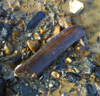
We then continued with a bit of drawing, as we wanted to get as many of the numbered features drawn as possible. Basically, we were able to get them all done up to the (possible) crane base. This all proved unproblematic, but we had a little surprise when we came to clean up the (possible) mooring feature, ready for drawing.
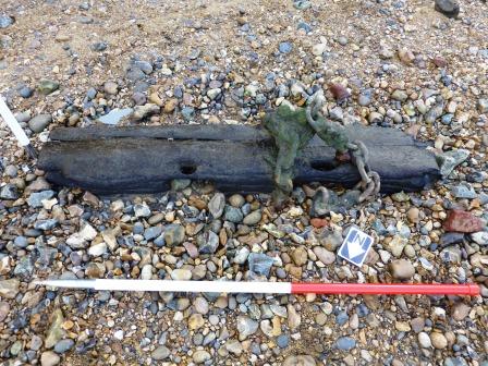
As we brushed away some of the surrounding stones and sand, the feature grew and grew until we had half-as-much again on top of (well, underneath actually) what we had previously.

It looks like a bit of ship’s timber, reused for mooring. There is a chain attached to it which, although it is pretty cruddy, is still flexible enough to move around.

Next we went to have a look at the large pipes which run down the foreshore and into the river. We have always assumed that these are gas pipes, associated with the 19th century gas works that stood on what became Albert Embankment. However, we decided that we would need to do a little bit more investigation into this in case they just might be associated with something else, possibly the hydraulic power network. There was a lot of industry around here, so there’s always that possibility.

We really want to get good drawings of these pipes, as they quite extensive and go quite a long way out into the river. We also spotted another one and some more connectors just a little way down stream, so we’ll be including those in the plan of these features. As, due to their size, the measuring and drawing etc of these would be a bit tricky with just me (Sunny) and Roger, we were hoping out loud that Anne would be able to join us, when who should appear but Anne herself! As the tide had already turned by then, it was too late to do the drawings there and then, but Anne was able to get a good look at the task, so we’ll be scheduling a day specifically for that (FROGs, look out on the FROG Network).
On our next visit (an evening visit. It’s on the FROG Network) we’re going to be doing some very specific drawing of the riverside wall. Much of the wall is a bland solid grey of sprayed concrete, but there is a particular little section where all sorts of things are going on.

We know, from the brilliant Bomb Sight website (below), that there was a high-explosive bomb strike here some time between October 1940 and June 1941 and it’s possible that what looks like hasty repairs to the riverside wall could be associated with that. As there’s probably not much record of this repair, we intend to make a fairly detailed drawing of the extent of the damage and the various bits and bobs that have used as filler.

This bit of wall is also the perfect site to consider erosion on this stretch of river. We always look at the erosion that is happening at the low-water mark, but there is clear evidence of erosion, and deposition for that matter, up at the top of the foreshore.
On this stretch, we have some remarkably clean-looking brickwork at the bottom of the wall; the exposure of previously covered brickwork indicating the drop in the foreshore level. A look at the bolts which hold these large timbers to the embankment wall also shows this up.

The upper bolt in this image (above) looks exactly as you’d expect, a bit green, a bit gunky, showing signs of the usual wear and tear that comes with being subjected to the Thames and all its comings and goings.
The lower bolt, however, looks like it hasn’t seen the light of day since the moment it was installed.

We only see it now because several inches of foreshore has gone, revealing clean wood and shiny new bolts.
As always, we retired to the Portuguese cafe for post-foreshore refreshments and a rant about the awful political parties we’re going to have to sift through on Thursday. The weather was so nice, we sat outside for the first time in 2015 😀
TTFN
.
.
NB, when we clean around features for drawing we use only brushes, no scraping or digging implements. And we always replace the stones, sand, whatever that we move, so as not to exacerbate erosion on the site. We don’t want to be the cause of our features floating away!
Islands in the stream
The weather has been glorious, sunny, bright and warm. So why on earth did we choose such a flippin’ freezing cold day for our April visit to Vauxhall?
Well it must have been that lovely low tide forecast: 0.08.
Roger and me (Sunny) were joined once more by fellow FROG Anne.
If you’re here hoping for mesolithic timbers, you’re going to be disappointed because that’s not what we were about on this visit (have a look at the previous post instead. There are mesolithic timbers galore there). As we’ve completed the new Alpha (Beta?) Survey, we’re now starting on drawing each feature. We’re being doggedly systematic about this, starting at the far eastern end of the site, nearest Albert Embankment, and just working our way along drawing every feature. This may take a while, as we’re only a teeny FROG.
Most of the features at this end are 19th and 20th century industrial; timbers, barge beds, what looks like a crane base, what we think is a mooring feature, gas pipes, that kind of stuff. We’ve yet to come across a single person who is even remotely interested in this stuff, besides ourselves, as everyone is more interested in prehistoric timbers, but all of this more recent foreshore archaeology will soon be gone, swept away by the coming of the Super Sewer. We still have no word on when this is likely to happen, but once this archaeology is gone, it’s gone. We think that this archaeology is worth recording, as it represents the history of this area just as much as the prehistoric timbers, fish-traps and bronze age structure. What’s more we have other evidence available for this more recent time period in the form of photographs, paintings and maps, so we should actually be able to build a coherent story of this little patch of industrial London. It may not be glamorous, but it’s a part of what made London.
So here they are. We have a number of boring square timbers.

But it’s possible that this particular boring square timber corresponds to the structure in this photograph from 1898 (taken during the demolition of the old Vauxhall Bridge, in the background).

This feature (below) has also been intriguing us. Three timber boxes with concrete infills. There isn’t much of the timber left, but the concrete was definitely poured into a timber surround.

We’ve been wondering if it’s a base for a small pier or something like that, perhaps associated with the gas works. This Stanford’s map from 1862 shows a ‘Coal Wharf’ immediately downstream of the gas works, so perhaps there was a small pier or jetty here.

But it’s also just possible that it’s something to do with a set of stairs called (variously) Gunhouse Stairs, Bombhouse Stairs or Gunner’s Stairs. I haven’t been able to find out much about this access point, but it is mentioned on a couple of maps and in ‘A Topographical Dictionary of London and Its Environs: Containing Descriptive and Critical Accounts of All the Public and Private Buildings, Offices, Docks, Squares, Streets, Lanes, Wards, Liberties, Charitable, Scholastic and Other Establishments, with Lists of Their Officers, Patrons, Incumbents of Livings, &c. &c. &c. in the British Metropolis’ (1831) by James Elmes (this snappily-titled text is available on Google Books)*.

The three main chunks of the feature also seem to line up with some other smaller timbers, so we’re going to be having a more detailed look at this next time and we’ll keep digging (metaphorically) to see what we can find out.
As we benefited from a lovely low tide, we were happy to see that the foreshore was visible all the way along Albert Embankment to The Thamesis Dock, the moored boat/cafe/bar. We couldn’t remember seeing the foreshore exposed this far along before, so we decide to take a walk along and see what there was to see.

So much debris. Seriously, SO MUCH DEBRIS. Some of this may be debris from WW2 bomb damage, as there was a bomb strike here.

And bottles. I don’t think I’ve ever seen so many complete glass bottles on the foreshore. Anne spotted the very best one.

And we got to see one of the Thames Islands.

We often hear about the earlier Thames, shallower and wider, with islands in the main stream. Well despite the embanked Thames being so much faster and deeper, we do still get these islands forming. They’re only visible at very low tides, but the one off Albert Embankment was visible during our visit and is actually quite large.
Also, as usual, we found an assortment of oddities and hazards.


As is so often the case, the tide turned on a sixpence and, as we had no wish to end up on the evening news being rescued from the rising waters by Tower RNLI, we beat a hasty retreat and headed for the cafe for a cuppa and a pastel de nata. Our next date will be posted on the FROG Network, so feel free to join us for that if you like (we’ll be doing more drawing).
*This book is an awesome resource and free to download, so if you’re interested in every random alley, yard, square and lane in London, I’d recommend that you look it up.
Thames Discovery Programme

